• -5%

Percorsi Invernali Alpe Devero

9788899606039_2018

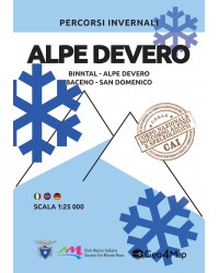
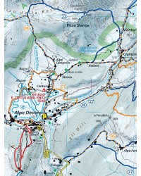
Alpe Devero winter hiking map:
Binntal, Baceno, San Domenico.

€12.00
€11.40 Save 5%
Tax included

100% secure payments
 

Shipments

The Geo4Map winter hiking map is made at 1:25,000 scale with the WGS84 UTM zone 32N reference system, with a broad representation of the territory in color and with an easy-to-fold accordion fold.

Cartographic contents:

  • Ski mountaineering itineraries and snowshoe routes indicated according to difficulty;
  • Closely visible coordinates for use in conjunction with GPS;
  • Level curves at 20 metres;
  • Three-dimensional model of the terrain;
  • Hand-drawn rock details;
  • Topographic information such as rivers, mountains, towns, roads enriched by other elements such as cliffs and cycle paths;
  • Legend in four languages: Italian, English, German and French.

On the back:

  • List of routes with starting point, arrival, heights, differences in altitude, travel times and difficulty measured with the Blachère and Toponeige scales;
  • How to read a map, use of the compass, orientation notions and the most common nodes;
  • Useful information for first aid: make an emergency call, first assist yourself or injured people or deal with inconveniences such as insect bites, cuts and illnesses;
  • The contents are in three languages: Italian, English and German.

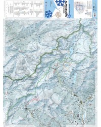
The geo-referenced cartographic bases are supplied to the National Alpine and Speleological Rescue Corps to allow better communication between rescuers and hikers in difficulty.

Printed on:

Available in digital format on:

9788899606039_2018

Data sheet

Height
68 cm (formato chiuso 19 cm)
Width
91 cm (formato chiuso 13 cm)
Material
Stone Paper
Packaging
busta cristal
Scale
1:25 000
Language
Italian, English, German
ISBN
9788899606039

Specific References